Population Statistics of Canada
The population of Canada, as of 2016 is 35,872,748 people (an .80% growth rate).

Canada is the 2nd largest country in the world, second to only Russia. However, the population is so low because most of the country's vast land is inhabitable due to its cold Northern climate.
 |
| Source: National Geographic |
Birth Rate:
10.29 births/1,000 population
Death Rate:
8.31 deaths/1,000 population
Total Fertility Rate:
1.59 children born/woman, ranked 184th in the world
Infant Mortality Rate:
4.71 deaths/1,000 live births
Urban Population:
The urban population of Canada is 81.8% of the country.
The largest metropolitan area of Canada is the city of Toronto, Ontario (2.615 million people)
 |
| Source: World-Visits |
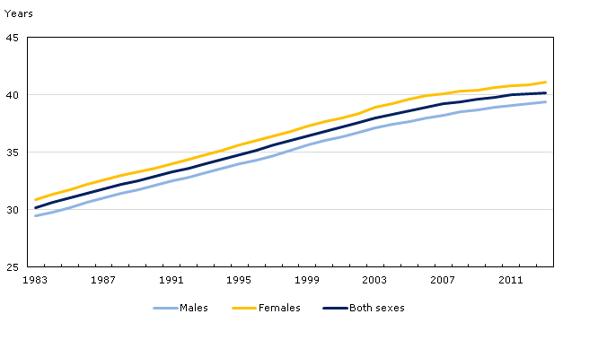
Median Age:
Men - 39.0 years
Women 41.0 years.
The average of the two would be 40.0 years.
Life Expectancy at Birth: 81.24 years
 |
| Life Collective |
HIV/AIDS:
As of 2014, the amount of Canadians living with HIV is an estimated 75,500. The prevalence rate is .2% of people. It is estimated that 21% of people infected by HIV were not aware they had the disease as of 2014.
Obesity:
The obesity rate in Canada is an estimated 24%, which is around average and similar to a number of other countries in the world. This is also a steadily increasing number for Canada. See below:

Literacy & Unemployment Rates:
It is reported that, as of 2014, roughly 42% of Canadians between ages 16 and 65 have low literacy skills. This results in 58% of people in that age range having better literacy skills.
Unemployment Rate in Canada as of 2015 is 6.90%, ranked 78th in the world.


